
From West-Central Indiana to a Statewide Movement
Conservation happens locally, but its impact reaches far beyond any one property, preserve, or organization. Indiana Land Protection Alliance's annual State of the Lands report highlights that collective impact, showcasing conservation successes from across the state and the organizations working together to protect Indiana's natural and agricultural landscapes.
We are proud to share that Ouabache Land Conservancy was featured in the 2026 edition of the report. Our story focused on the successful installation of the Motus Wildlife Tracking System tower at Atherton Island Natural Area, a project that connected west-central Indiana to an international network of wildlife researchers studying bird and bat migration.
A Statewide Conservation Community
State of the Lands highlights the work of land trusts and conservation organizations from across Indiana, showcasing projects ranging from habitat restoration and scientific research to farmland protection, public access improvements, and wildlife conservation. Together, Indiana's land trusts and conservation partners protected 3,193 new acres, restored more than 11,000 acres of habitat, maintained 288 miles of trails, and engaged more than 38,000 people through outreach events in 2025. The report also notes that Indiana land trusts now protect more than 187,000 acres across the state.
Those numbers tell an important story: conservation succeeds through collaboration.
While land trusts often focus on local landscapes, the challenges we face— things like clean water, healthy wildlife habitat, outdoor recreation, and land stewardship—extend beyond any single property or organization. The State of the Lands report demonstrates what becomes possible when organizations share knowledge, resources, and expertise in pursuit of common goals.
OLC's Contribution
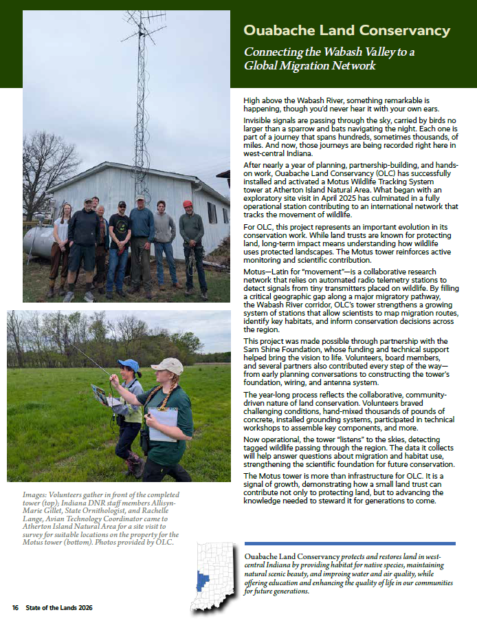
This year's report featured OLC's Motus Wildlife Tracking System tower at Atherton Island Natural Area. After nearly a year of planning, partnership-building, and volunteer effort, the tower became operational in 2025 and now contributes data to an international research network that tracks the movements of birds and bats across North America. The project filled an important geographic gap along the Wabash River corridor and represents a growing role for OLC in supporting scientific research and wildlife monitoring.
The project was made possible through partnerships, volunteer support, and funding from the Sam Shine Foundation. Like so many conservation successes, it reflects the power of people working together toward a shared goal.
Looking Ahead
For OLC, being included in the State of the Lands report is both an honor and a reminder that local conservation is part of a much larger story.
Whether restoring habitat, improving water quality, building trails, monitoring wildlife, or protecting land for future generations, every project contributes to a broader conservation effort happening across Indiana.
We are grateful to Indiana Land Protection Alliance for highlighting conservation successes from around the state and for the work they do to support and strengthen Indiana's land trust community.
Interested in exploring this year's report? The 2026 State of the Lands publication is available through the Indiana Land Protection Alliance and offers inspiring highlights and milestones from conservation organizations across Indiana.